Geocaching & Trail Map
Geocaching
What is geocaching you ask? Geocaching is an outdoor treasure-hunting game in which a Global Positioning System (GPS) receiver is used to find containers anywhere in the world. A typical cache is a small waterproof container containing a logbook and “treasure,” usually toys or trinkets of little value. You can visit www.geocaching.com to learn more about geocaching.
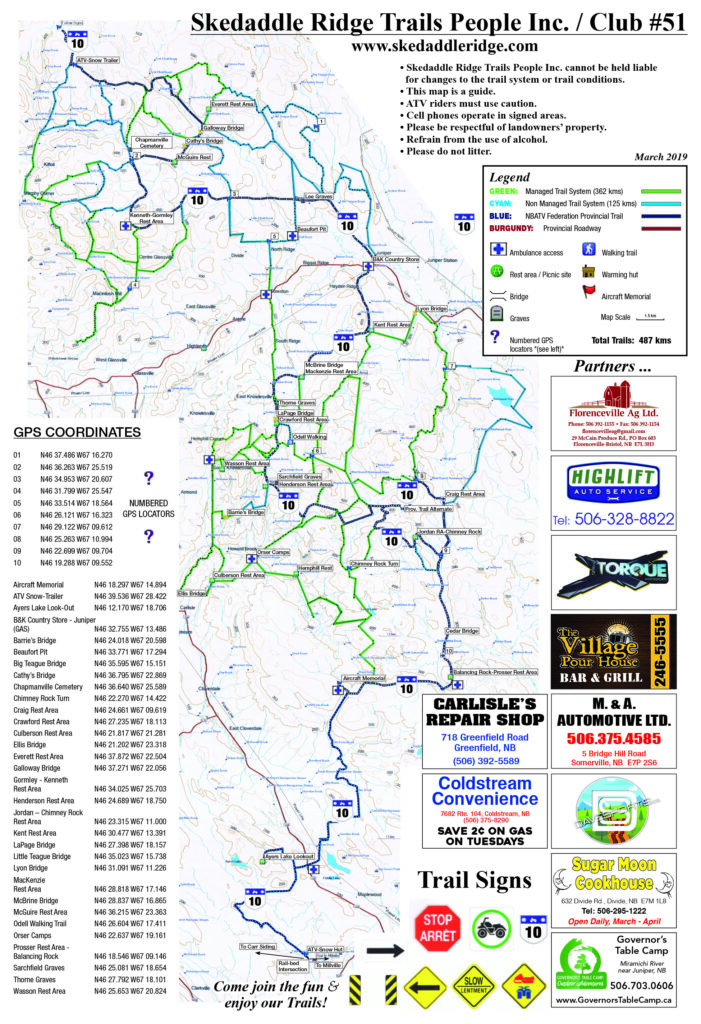
You will find Skedaddle Ridge boxes at the following GPS co-ordinates. Please do not move the box from this location. Place your replacement gift in the box, ensure it is secure and place it the same way you found it. The next person who finds the box will have the same challenge you enjoyed. Skedaddle Ridge will continue to place more GPS boxes at points of interest in the near future. Please check this website to be certain you have the latest information on their location. Have fun!
GPS Waypoint locations:
# 1 N 46 26.234 W 67 19.911
# 2 N 46 27.783 W067 18.131
#3 N 46 31. 253 W 067 11.132
#4 N 46 24.481 W 067 09.565
#5 N 46 24.620 W 067 13.920
#6 Warming Hut (micro) N46 39.544 W67 28.680
#7 Bridge N46 39.012 W67 26.894
#8 Way to Arthurette (micro) N46 38.918 W67 25.342
#9 Yellow Sign (micro) N46 39.028 67 24.487
#10 The Big Turn N 46 39.464 W67 22.587
#11 Intersection (small) N46 37.512 W67 321.963
#12 McGuire Rest (micro) N46 36.239 W67 23.358
#13 To Look Out N46 34.216 W 67 25.419
#14 The is Honey in these Hills N46 35.112 W67 22.806
#15 Money in those Hills (small) N46 34.987 W67 20.486
#16 Four Corners N46 34.920 W67 17.343
#17 Ernie’s N46 27.743 W67 18.128
#18 RIP N46 34.928 W67 16.870
#19 Corner Cache N46.27.863 W67 20.057
#20 Teague Brook N46.33.472 67 13.965
#21 More Sweets In Those Hills N46 27.072 W67 20.306
#22 Near Juniper N46.32.712 W67 13.318
#23 The Tee N46.26.220 W67 19.918
#24 Frog Pond N46 31.636 W67 13.363
#25 Covered Bridge Nowhere N46 28.812 W67 17.144
#26 Another ‘T’ N46 18.321 W67 13.172
#27 Along the Nashwaak N46 22.876 W67 09.668
#28 Brook N46 18.194 W67 09.607
#29 Craig Rest N46.24.668 W67 09.615
#30 Prosser’s N46 18.537 W67 09.127
#31 Old Warming Hut N46.24.442 W67.12.904
#32 South Sister’s N46.19.473 W67 09.409
#33 The Nashwaak N46.20.855 W67 09.586
#34 Blue N46.30.452 W67 13.442
#35 Along the Nashwaak N46 22.146 W67 09.791
#36 Crooked Tree N46 29.801 W67 15.224
#37 Road to Henderson Rest N46 25.299 W67 18.652
#38 The Pirate Might Get You N46 23.804 W67 14.634
#39 Hunter’s Camp N46 24.716 W67 17.544
#40 Spruce Tree N46 24.445 W67 13.419
#41 Purple Top N46 24.213 W67 16.700
#42 Another ‘Y’ N46 24.323 W67 11.564
#43 Thorne Monument N46 24.187 W67 16.700
#44 Three Trees N46 24.361 W67 15.568
#45 The Pines N46 25.251 W67 10.887


